PavLab Photos/Events
- MechE News/March2025
- 2.680 Spring 2024
- Jervis Bay 2023
- Aug 23rd 2023
- Aug 3rd 2023
- Open House 2022
- Photo Archives
Current Lab Robots
Current Projects
- MOOS-IvP
- Swarm Toolbox
- HydroMAN
- MIT Sea Beaver UUV
- USV Model Estimation
- MOOS-IvP-Multi
- Blueboat Autonomy
- Spurdog UUV
- Skywalker
- DARPA LINC
- Stochastic Ray Trace
- MTASC
- Advanced COLREGS
Current UGrad Projects


Robot Archives
Project Archives
- Swarm Declustering
- PBACS
- Prodromos
- RoboWhaler
- Autonomous Fish Finding
- Sea Train
- Multi-Arch Autonomy
- Morpheus
- HydroLink Buoy
- Perseus
- IITCHS
- Remote Explorer IV
- Aquaticus
- Charting the Charles
- Boston Harbor RoboChallenge
- COLREGS Autonomy
- ICEX 2016/2020
Help Topic: Pavilion Coordinates
Maintained by: mikerb@mit.edu  Get PDF
src: project-pavlab/helpdocs/help_pav_coords
Pavilion Coordinates
The MIT Sailing Pavilion is the center of operations for the Pavlab, or Marine Autonomy Lab. The (0,0) coordinates, or datum, is located at: 42.358436, -71.087448. These datum coordinates are declared in the top of every .moos file in missions run at the MIT Sailing Pavilion, and set in the plug file plug_origin_warp.moos:

 // MIT Sailing Pavilion  (updated 4/22/25)
 LatOrigin  = 42.358436
 LongOrigin = -71.087448
All other coordinates are usually configured in local coordinates relative to the above datum.
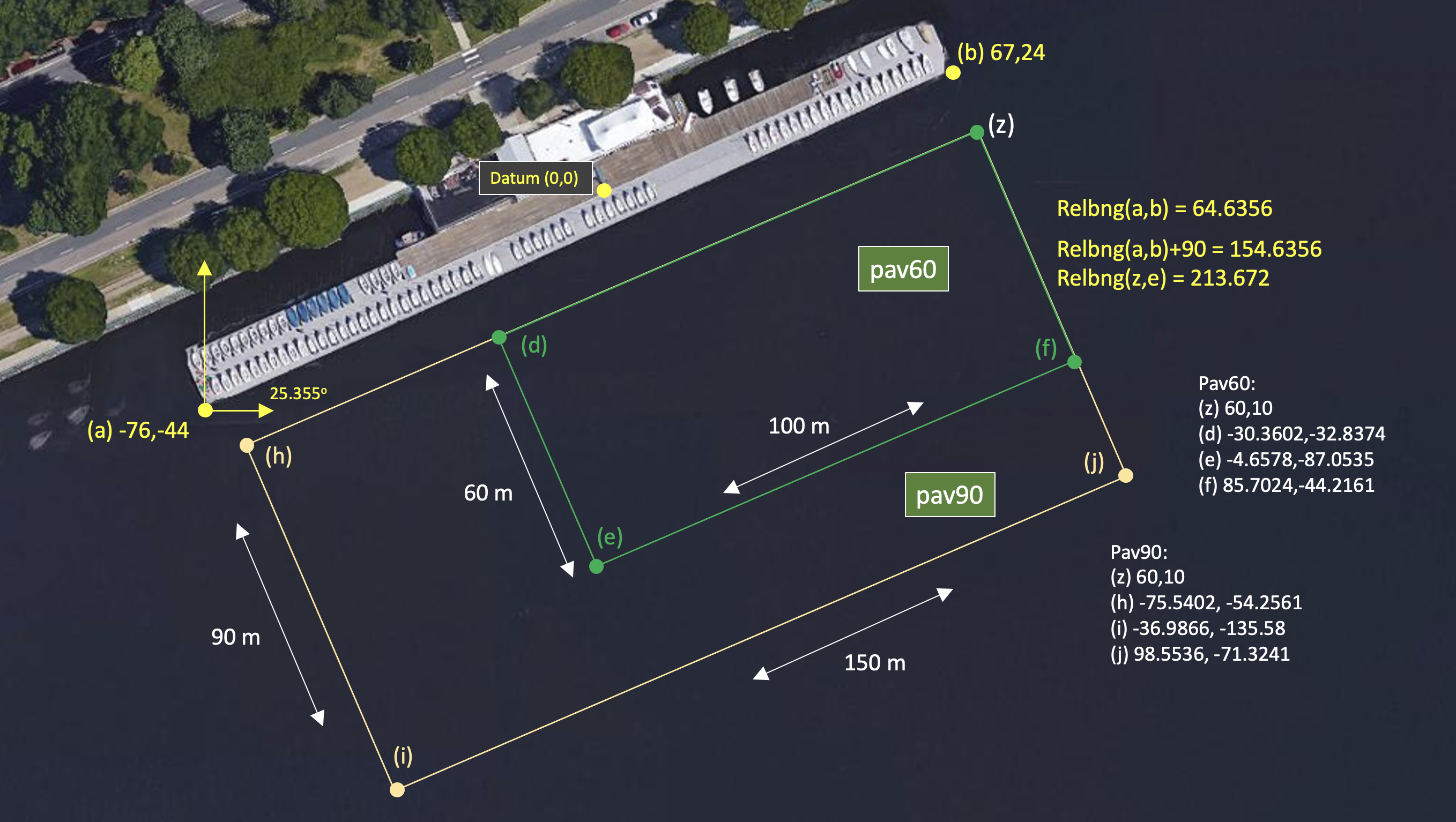
Figure 1.1: Useful coordinates related to the rescue lab. There are two playing field rectangles, a large one ("pav90") roughly the extent of the docks, and a smaller region ("pav60") closer to the Pavlab doors on the East end of the dock.
Note there are two rectangles representing a small and large operation area. The smaller area (pav60) is typically used for in-water tests involving one or two vehicles. The larger area (pav90) is typically used for in-water tests involving more vehicles.
   pav60: pts={60,10:-30.3602,-32.8374:-4.6578,-87.0535:85.7024,-44.2161}
   pav90: pts={60,10:-75.5402,-54.2561:-36.9866,-135.58:98.5536,-71.3241}
Coordinates are generated with the support of the pavop.sh script, found in moos-ivp-pavlab/scripts/.
Document Maintained by: mikerb@mit.edu
Page built from LaTeX source using texwiki, developed at MIT. Errata to issues@moos-ivp.org. Get PDF